Seabed Mapping Project
Seabed maps and benthic (seabed) ecological data aid marine spatial planning and inform the decision-making processes involved in achieving sustainable management of the demands placed on our marine environment. Seabed mapping provides foundation data to assess the impacts of industry (such as electricity and telecommunication cable route planning, offshore renewable energy and leisure sectors) as well understanding the effects of management interventions and conservation designations.
Seabed mapping capability
AFBI is a founding member of the UK Centre for Seabed Mapping (UKCSM) which is a multi-agency, collaborative network striving for cross government co-ordination and integration of operational activity and promotion of seabed mapping focussing on four priorities: Data Collaboration, Data Standards, Data Accessibility and Data Collection.
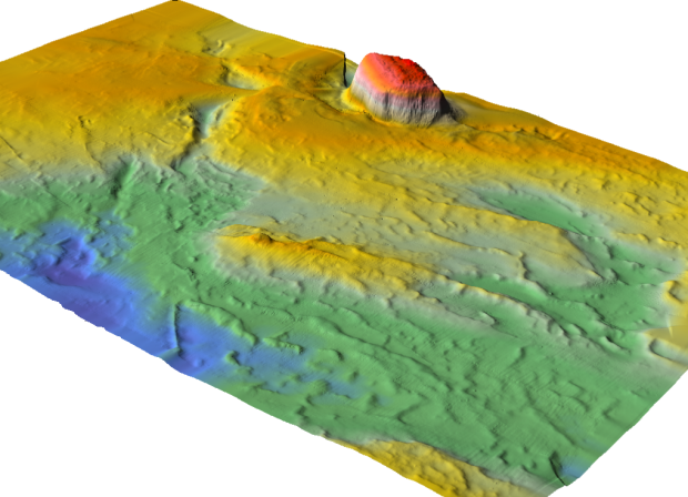
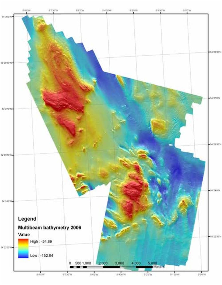
Example bathymetry for Torr Head, Dundrum Bay and South Down coast are provided here:
This state-of-the-art equipment significantly enhances AFBI’s capability in the field of seabed mapping to be carried out to the highest international standards.

As well as its own programme of research, e.g. developing the use of Optimum Allocation Analysis for seabed habitat mapping, AFBI was recently involved in the EU Funded Mapping European Seabed Habitats Project.
Habitat mapping and fisheries
Habitat maps may be used by fisheries managers to map and quantify resources to direct fishing effort in order to develop more effectively management regimes. More problematic for the same managers is the need to identify potential closed areas which may reduce the area available for fishing both on a spatial and a temporal basis. In the past, the industry has regarded the use of habitat maps with suspicion regarding them simply as a tool to restrict their activities.
The adoption of a spatial planning approach in which habitat maps are a central tool has had only a patchy uptake by fisheries managers although there is some notable success in the shellfish sector. However, as the management of fisheries continued to move to an ecosystem management approach it is to be expected that habitat maps will play a central role in policy making.
The fishing industry itself has long recognized the value of many of the techniques developed for habitat mapping and may well be regarded as a stimulus for the development of Acoustic Ground Discrimination Techniques.
The shellfish aquaculture sector with its tradition of licensing areas of seabed has had a history of realizing the value of maps in managing their industry. The use of acoustic techniques for locating and quantifying resources has gained widespread acceptance in this sector.
Habitat mapping reports 2015
The following reports were delivered under the Service Level Agreement between the Agri-Food and Biosciences Institute (AFBI) and the Department of Environment (DoE), Environment and Marine Group, Water Management Unit & Marine Division in respect of scientific and technical services (2014-2015).
AFBI Fisheries and Aquatic Ecosystems Branch, October 2015
Mapping Reports 2016
AFBI was awarded a contract to assist the Department of Agriculture, Environment and Rural Affairs (DAERA) in the designation of an area of seabed of the Outer Ards Peninsula as a Special Area of Conservation. It required gathering existing data (from a range of data holders) and undertake additional survey to provide information on the characteristics and nature of the seabed and co-associated biota in the region of Craigbrain and Burial Island, with a particular emphasis on Horse Mussel (Modiolus modiolus) Biogenic Reefs. The aim of the project was to specifically map the extent and condition of the reefs using EU/Joint Nature Conservation Committee guidance which will enable the Department to design the boundary for the proposed SAC, detailed site selection documentation and Conservation Objectives. The final contract report is available to read Assessment of Outer Ards Modiolusmodiolus biogenic reefs against Special Area of Conservation (SAC) criteria
Survey planning tool: optimum allocation analysis and ground truthing
Seabed habitat mapping is an increasingly popular activity worldwide, coinciding with rapid methodological development and technological advances such as multibeam echosounders, acoustic ground discrimination systems and sidescan sonar. The ultimate difficulty lies in the substantial survey effort required to physically confirm the acoustic readings and relate these to the biology of an area. Ground-truthing strategies have rarely been adequately addressed or even specified within published benthic mapping literature. Precisely how the first stage physical survey informs the ground-truthing is poorly defined and occasionally complex. Most rely on expert judgement, while in some advanced studies the ground-truthing strategy uses identified acoustic ground-types with sampling being related to ground-type area.
By integrating the areas and variances, a statistical method such as Optimum Allocation Analysis (Sukhatme & Sukhatme, 1970; Cochran, 1977) could calculate surrogate ground-type heterogeneity values to direct ground-truthing effort. Optimum Allocation Analysis (OAA) may be defined as a procedure used in stratified sampling to allocate numbers of sample units to different strata to either maximize precision at a fixed cost or minimize cost for a selected level of precision.
The parameters used to define the population can be any derived acoustic variable, e.g. bathymetry, slope angle and acoustic backscatter. Subpopulations, or ‘strata’, are the ground-types that the remotely sensed data are classified into prior to being confirmed with ground-truthing.
Actual values should be standardised through simple linear re-scaling on the 8-bit grey level image scale of 0-255: this allowed calculation and comparison of means and standard deviations for all variables. The summary statistics (mean and variance) can be entered into a Microsoft Excel Macro containing embedded calculations for OAA. The area of each predicted ground-type will be shown in m2.
- Optimal allocation analysis macro (Excel 101KB)
- Optimal allocation analysis macro user guide(PDF 126KB)
The coefficient of variation (CV) can be adjusted for calculating the optimum sample numbers per ground-type. It must be stressed that although OAA recommends the area of seabed to be sampled, it does not advise where these should be placed within each ground-type, how they should be distributed amongst patches of the same ground-type or what sampling equipment should be used. Once the ground-truthing data are collected, it is possible to use the OAA in reverse.
It is hoped that this Macro will provide a dialogue and framework for future consideration of how the science of benthic habitat mapping can be significantly advanced. If used in a cited report, please reference:
Clements, A. J., Strong, J. A., Flanagan, C., and Service, M. 2010. Objective stratification and sampling-effort allocation of ground-truthing in benthic-mapping surveys. – ICES Journal of Marine Science, 67: 628–637.
References
Cochran, W.G. 1977. Sampling Techniques; Third Edition. Wiley Publications in Statistics, New York, United States of America.
Sukhatme, P.V., and Sukhatme, B.V. 1970. Sampling Theory of Surveys with Applications. Iowa State University Press.
Ireland, Northern Ireland, Scotland Hydrographic Survey (INIS Hydro) Project
Project website:
The INIS Hydro project is coordinated by the Maritime and Coastguard Agency and builds on the work of JIBS (Joint Irish Bathymetric Survey ) by surveying new areas of seabed including a substantial survey in Scottish waters. The project supports strategic cross-border cooperation for a more prosperous and sustainable region. The total cost of INIS Hydro will be in the order of €3.2 million.
The objective of the INIS Hydro Project is to promote joint action to survey the seabed in such a way as to satisfy the needs of many organisations in the bordering regions. INIS Hydro focuses on surveying sensitive bays and inlets on the coasts of the bordering regions.
The main aims of the INIS Hydro Project are to:
- provide, for the first time, comprehensive multibeam bathymetry data in areas of identified strategic importance
- obtain ground-truthed (by grab sampling), geo-coded backscatter data for the surveyed area
- provide seabed texture sheets for the surveyed area showing interpreted seabed types
- serve up multibeam bathymetry and backscatter data as “Generic Sensor Format” and “ASCII XYZ” files on the world-wide web
- work co-operatively to ensure results are compatible with the needs of all regions and to foster better technology and procedure transfer between the partner organisations
- provide bathymetry data to the United Kingdom Hydrographic Office to enable updating of nautical charts and publications in Scottish, Northern Irish and Irish waters to improve safety for mariners
- make available and proactively disseminate up-to-date seabed maps and associated data sets (including information on bathymetry, habitat type and environmental conditions) to stakeholders, key end-users and the public
- contribute to meeting the requirements of the Marine Bill (UK), the Sea Change Strategy (Republic of Ireland) and the Integrated Maritime Policy for the European Union.
The existing charts of the surveyed areas are severely outdated and are unsuitable for efficient marine stewardship. A comprehensive multibeam survey provides an extremely detailed foundation map that, in addition to fulfilling the National Safety of Life at Sea requirements, will underpin all forms of marine data, including habitat and environmental data; permitting oceanographic modelling and marine spatial planning.
The key products arising from this programme will include digital data and maps illustrating:
- 100% coverage of seabed bathymetry as an aid to navigation
- 100% coverage of acoustic backscatter to identify seabed bottom type
- marine geology derived from the above
- currents, tides, temperature and salinity measurements in the water
- identification of benthic habitats and
- underwater archaeological heritage